Sunday, August 09, 2009

Pictured Rocks - Day 1

For the 4th of July weekend, we headed to one of our favorite places - Pictured Rocks National Lakeshore, just east of Munising.


Our first stop was an overlook of the sandstone formation known as Miner's Castle. The late afternoon sun gave a nice greenish-blue tint to the water, adding to the scenery.


The last time we saw Miner's Castle in 2003, there were two turrets. Apparently, erosion & frost heave got the best of the right turret, which fell off and dropped in the lake in April 2006.


We thought we would take a chance for the photo op while our hair still looked halfway decent (well, at least Sara's).


A view from just east of Miner's Castle, again sans the turret that used to be infront of the remaining turret.


Sara playing with the camera equipment and pretending she knows something about photography.

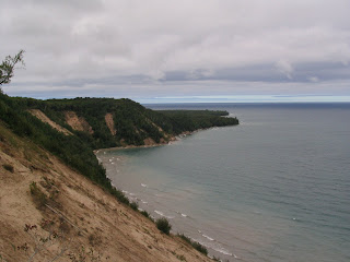
The sandstone cliffs east of Miner's Castle rise up out of the lake. Can you see the arch?

If you couldn't see it in the last one, you can see the arch in this one.


The telephoto allowed us to get a close up of the sandstone cliff formations.


The tour boat gives a sense of scale to the cliffs.


Ahhh! Tourists!

After setting up camp at a forest service site, we thought we would try and make it to the beach in Grand Marais before the sunset. On the way, we saw a pretty scene of a lone tree with the sunset behind it too good to pass up for a photo.

We didn't quite make it before the sunset, but the lingering colors were still a beautiful sight from the Grand Marais 'pier.'


We spotted this house with the full moon above it, and thought it looked worthy of a photo prior to heading back to camp for some Zzz's.

Saturday, August 08, 2009

Pictured Rocks - Day 2

We awoke in the morning to brilliant sunshine at the Ross Lake National Forest campground just south of the park boundary.


Pat caught a shot of this cute little chipmunk on the fire pit ring.


Since there was minimal wind, the lake was smooth as glass.


The campground host's boat beckoned to be taken out for a spin.


The water was so calm & clear, it was almost difficult to tell where the beach ended and water started.


Even though the Ross Lake forest campsite was pretty nice compared to your average campsite, nothing beats the view at the Twelvemile Beach campground in the actual park. After packing up camp, we headed to the Twelvemile Beach to get a beachside site before they were all taken. We were able to find one with the usual spectacular view.


Another view of the beach from the campsite.


Last time we came to the the park, we hiked about 6 or 7 miles roundtrip to the Au Sable Light Station. We had thought this was the only way to get to it, and thought it was kind of nice that only people who were serious about seeing it could get to it. Well, this time around, we realized there is a short 1-mile trail between the Hurricane River campground and the lighthouse on the map. Since we wanted to maximize the number of sights to see on this trip, we thought we would try the short trail, thinking it would still be the usual rugged trail. It turned out to be almost embarrasing for us to 'hike' on this trail - it was a two track that my car could drive down, & we ended up passing numerous people in their 80s! Oh well, we'll have to take the more scenic route again next time. The view of the lighthouse was still no less than fabulous.


Another view of the lighthouse from the tower side.


The Au Sable light station was built in 1874. The tower stands 87 feet high and used to hold a 3rd order Fresnel lens, which is now at a museum in Grand Marais.


Let me in!


Ah, our new home - I wish!


I could handle this view every day. Might be a little chilly to sit on the porch in the winter, though.


This light station was designed by engineer (of course) Orlando Metcalfe Poe, who designed several Great Lakes lighthouses and other maritime structures, including the New Presque Isle lighthouse on Lake Huron where we were engaged.


The fog signal building and a maintenance building east of the lighthouse are partially shrouded by the tall grass.


A view of the Grand Sable Dunes from the beach infront of the lighthouse.


I'd definitely take this for my beach view over some tropical destination! The beach traffic is just about right, too.


A nice wood crib retaining wall & gabion structure keep the fog signal building from sliding into the lake.


We were entertained by a Kildeer bird on the beach that kept trying to pretend it had one, then two broken wings to lure us away from her nest of cute little chicks.


We saw this beautiful ladyslipper flower on the trail back to the parking lot. Apparently this is actually supposed to be the state flower of Minnesota, yet I have only seen them in Michigan!


Its the Carribean, wait, its, Grand Sable Dunes? Having been to the Bahamas, I would say this is actually a better view. If you look hard, you can see the top of the Au Sable light tower near the end of the point.


It is amazing what an SLR camera, hunk of Canon 'L' glass, and a decent polarizer can do. The sun helps a little, also. I dug up this photo from our last trip to the dunes in 2004 that we took with our point and shoot digital, and it doesn't even look like the same place.


A shot of the dunes looking eastward towards Grand Marais. I love our camera!


Even a picture with us infront of the dunes cannot give you a true sense of scale. The dunes are up to 275 feet high at some points, and have a slope of 35 degrees (pretty darn decent for rounded sand particles). The dunes were created and continue to be maintained by aeolian (wind) action blowing sand up on shore.


We broke out the telephoto for a shot of the light station tower from the dunes.


We drove eastward to the Sable Falls area, and hiked a bit on some dune trails where the dunes were a little shorter. The view of the Lake was still spectacular.


Pat looking eastward towards Grand Marais. The little speck near the shoreline is a person walking their dog.


On the way to and from the dunes from Sable Falls, we walked across this intesting bridge along the trail. We'll let you make your own conclusions!


We didn't mind a few intermittent clouds covering the sun while taking photos of Sable Falls.


A zoomed out view of the falls.


We continued eastward to Grand Marais where we saw the Coast Guard station. Apparently, this station was the last to be in contact with the Edmund Fitzgerald before it sank.


Back at the campsite, I caught a photo of Pat before heading down to the beach.


Rocks, anyone?


We saw a small flock of Canadian geese also enjoying the beach.


Of course as I slowly moved toward them, they made a beeline for the Lake. I was still able to catch them with the telephoto.


I think our house would look nice on top of the hill to the right......


Pat relaxed on the beach and read a book while waiting for the sunset.


No clue what these flowers are. I thought they were cute, so I had to break out the Lensbaby to get a photo.


White pine branches look pretty cool through the Lensbaby lens, too.


And so do pinecones on the beach basking in the late evening sun.


Yes, I could definitely move here.


Although not completely spectacular due to the lack of accessory clouds, the sunset was still pretty nice.


We caught a last glimpse of the sun with the telephoto just before it dipped below the horizon.


The remnant sunset continued to be beautiful for a while after the sun had gone down.


We had so much fun with the fire shots at the Porcupine Mountains, we thought we would try a few more this time.


We warmed up by the fire right before hitting the sack.