Monday, February 09, 2009

McKinley Bar Trail

Our third day in the park was spent on the McKinley Bar Trail. The trail starts from the Wonder Lake Campground and goes south to the McKinley River. We thought the McKinley Bear Trail was a more appropriate name due to all the bear signs we saw along the way.


We had lunch not far from where this photo was taken. Quent also took the opportunity to bathe in the liquid glacier more commonly known as the McKinley River. The rest of us folks with somewhat more sense utilized a camp shower filled with water warmed from our camp stoves.

We stopped at this pond on our return trip to kill some time and play some Frisbee.

On the way out. As we traveled back towards our campsite we noticed a few rain clouds off in the distance. As the level of concern started to rise Pat eased everyone's fears and stated "Don't worry. We'll be alright." With that said it started raining less than a minute later. Everyone was mostly soaked in the cold rain by time we returned back to camp, but everyone was alright! Thankfully just as we reached shelter, the sky really opened up in a downpour that rivals any of recent memory.

Wonder Lake

We spent our last evening taking a short walk from our campsite to Wonder Lake.


Wonder lake in the evening light.


Sara was acting up prior to taking this portrait. I of course had to set her straight.


Afer some behavioral coaching we both settle down long enough for this photo.


As the cool evening air settles in the lake begins to steam


We burned the last remaining daylight snapping photos along the shore before heading back to camp to settle in for the night.

Road Out

Our last day in the park we woke up early to beat out the the touring boyscout troop to the limited seats on the first bus out from Wonder Lake.


Using Quent and Christina's Telephoto lens we took this shot of a cow moose we spied along the road.


Mt. McKinley showed itself once again as we head east out of the park.


Our last view of Mt. McKinley and the road from which we came.

Denali Highway

After several days of backpacking we were all excited to hit the park headquarters for a warm shower and afterwards, a warm meal at a local restaurant. From Denali NP we headed south, back the way we had come until we reached the Alaskan/Denali Highway Junction. We then headed east along the infamous Denali Hwy.


The Denali Hwy was originally built to access the newly formed McKinley National Park. It was never paved and has remains a dirt road to this day. In this photo you can see the Nenana River to the right.


Sara poses with a smile with the Nenana River and Pyramid Peak in the background.


Sara was more open to a photoshoot after having recently had a hot shower and a chance to do her hair! What a babe!


Another shot of the Denali Highway looking west.


Overlooking Monahan Flat with the Alaskan Range beyond.

We made several stops along this stretch of highway to enjoy the scenery.


The girls smile for the camera.


Quent at the wheel. How could we go astray? Oh wait..... Look OUT!! :)


We stopped again near the Susitna Lodge, along the Susitna River of course. The Clearwater Mountains dominate the background.


This float plane was moored in the lake below.


Sunday, February 08, 2009

Tangle Lakes

After spending the night at the Tangle Lake campground we took a short hike down a nearby trail near the Amphitheater Mountains.


Looking towards Landmark Gap. Recent rains apparently flooded some parts of the trail leaving several large pools that we had to navigate around.

We stopped near this small lake for lunch on our way back to the truck. you can see the Alaskan range in the background.


The Alaskan Range in the distance.


This shot was taken near the Denali Highway/Richardson Highway junction. What I believe to be the the Gakona Glacier can bee seen in the distance.

Richardson Highway

After leaving the Tangle Lakes area of the Denali Highway, we headed north towards Fairbanks on the Richardson Highway.


Although not snow capped, the mountains were still beautiful.


The highway follows the Tanana River.


We stopped to stretch our legs & enjoy the scenery. We also had fun playing in the mud - aka saturated silt deposited by the river.


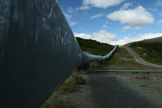
After being intrigued for several miles, we found a pullout by the Alyeska pipeline. This particular location is where the pipeline crosses the Denali Fault.


Of course being engineering nerds, we had to check out the rail system that allows the pipeline to shift laterally in the event of an earthquake.


Photo op. Think of all the oil flowing past us.....


A 48" diameter pipe....is not this big. The elevated 48" pipe is encased in 3.75 inches of insulation, making the total diameter of 55 1/2 inches.


Just north of the pipeline viewpoint, we were driving along and noticed a large brown figure in a pond. We turned around, and sure enough, it was a female moose.


From far away, the moose didn't look very big. I am sure if she was standing next to us, we would think otherwise.

Quentin & Christina lent us their telephoto lens, and we put it on the camera just in time for for the moose to show us her 'best' side.

Here's an example of the condition of a typical sign in Alaska. Rumor is they are favorites for target practice.

Here is a nice shot of a pipeline crossing under the highway. As a geotech, Sara was especially excited about the towers that follow along the pipeline, and in most areas support the pipeline. The towers act as heat exchangers by circulating ammonia to keep the permafrost frozen.


After a bite to eat in Fairbanks, the girls were very happy to get a chance to stay in a hotel for the night. Luckily the guys went for staying at the Chena Hot Springs Resort, about a half hour east of Fairbanks. This is supposed to be the 'hot' spot in the winter for watching the northern lights. The geothermal springs felt great considering the 'summer' temperatures in the 50s, and were a nice end to a fun day.