Some areas are paved, but the highway is mostly unpaved. Suprisingly enough, the unpaved sections tended to be smoother since they seemed to be frequently maintained by graders, while the paved areas had several dips due to areas of melting permafrost.

Of course the three of us nerd engineers had to make a stop to gaze at the E.L. Patton bridge that crosses the Yukon River. Christina seemed to enjoy the view, as well. The bridge is named after the president of the Alyeska Pipeline during pipeline construction. The road surface is wood planked, and the pipeline is carried along the east side of the bridge. Although it doesn't like it from this angle, the bridge has a 6% grade.

The parking lot at the Yukon River viewpoint also offered a nice view of the pipeline north of the bridge.

As we continued north, we started seeing interesting rock formations mixed with beautiful fall colors of tundra plants.


Some of the granite formations are granite pinnacles that are apparently called 'tors.' We stopped to see this particular tor called Finger Rock. The signs at this site mentioned that early bush pilots used this rock to guide them to Fairbanks, where it points.

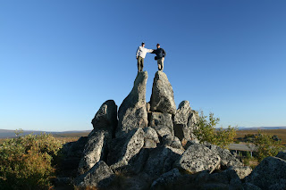
We of course had to take the opportunity to do a little climbing around on some other rocks at the Finger Rock lookout.

To infinity and beyond! Or maybe just northward.

Where's the polar bears? I had previously always imagined a barren wasteland of frozen tundra at the Arctic Circle, but luckily, we found it to be pleasantly 'warm' for being at latitude 66 degrees. The ground surface was at least thawed and the deciduous trees still had leaves.

We took advantage of a photo op for the Christmas cards.

A few others may have stopped here before us based on the evidence on the back of the sign.


No comments:
Post a Comment