Saturday, January 24, 2009

Coldfoot

After a short arctic night, we were awakened the next morning by a bus load of noisy tourists who pulled into the campground for pictures next to the Arctic Circle sign. To our relief, they did not stay long, and we started breakfast.


This Grey Jay joined us for breakfast. It's a good thing we had our fill of pancakes, otherwise he'd be in an inopportune place.


Coldfoot Pumping Station. Coldfoot is the only major outpost along the Dalton Highway until you reach Prudhoe Bay. We stopped here for diesel and to stretch our legs. The saying goes that Coldfoot received its name when one member of a mining party got cold feet and turned back around back towards Fairbanks. Thankfully there were no cold feet in our expedition party.


Outpost building in Coldfoot Camp.

View of the hills surrounding Coldfoot.


A short synopsis of Coldfoot's history.


Another rack on the side of the outpost building

Thursday, January 22, 2009

Gates of the Arctic

We headed north from Coldfoot towards our destination of the Gates of the Arctic National Park and the North Alaskan Slope.

Our first view of the foothills of the Brooks Range along the Dalton Highway.


This was our view of Sukakpak Mountain at a rest stop along the highway. As you can see the aspen are in full color and it is only August. The river in the foreground is the Middle Fork River I believe.


Fall colors covered the hills on both sides of the road.


The highway climbs upward into the Brooks Range and towards Atigun Pass.


This picture is taken from the North Slope looking at the north side of the Brooks Range. Lake Galbraith lies in the foreground.


A view of the tundra that comprises Alaska's North Slope.

Looking east at the northern foothills of the Brooks. The isolation and the desolation was amazing. Despite that however, the ground was covered with plants, floors and other forms of wildlife.


At a small rest area along Lake Galbraith we stop to stretch our legs. We pose for a photo to celebrate the northern most point either one of us has ever ventured. (Latitude ~68.5 degrees)


Pat rests on the "Moose" Guard on the front of the truck. The truck was on loan from Quentin's brother, Nate, who was generous enough to let us borrow it for a couple of weeks. Thanks Nate!


Another shot of the Brooks, looking south.


The Alyeska Pipeline traveling south from Prudhoe Bay, approximately 200 miles to the north.


Afternoon shadows fill the valley as the day draws to a close.


The sun broke through the clouds perfectly to create this amazing view of Sukakpak Mountain as we saw it again going back south.


The Wiseman Post Office. The unique climate of Northern Alaska can play havoc on a buildings foundation. The heated post office thawed the permafrost below which ultimately caused over a foot of settlement. The geotechnical engineer among us found this particularly fascinating.


The Coldfoot Station. The station consists of a fueling station, cafe, store, offices, and showers. All captured in one photo.


Choices. This sign greets us as we leave the Dalton Highway and return to the Elliot Highway on our way back towards Fairbanks.


Gold Dredge No. 8

On our way back to Fairbanks we passed the Gold Dredge No. 8. Curiosity got the best of us and we stopped in for a quick tour. The Gold Dredge No. 8 is one of the last remaining gold dredges left in northern Alaska. The gold dredge was manufactured in Pennsylvania by the Bethlehem Steel Company Ship Building Division in 1928 and shipped to Alaska to work the Goldstream Valley. The dredge remained in operation until 1959.

A view of the abandoned mine site.


Security looks sparse but I will say they are direct.


The gold dredge rests in the same location that it did at the end of its last work day in 1959.


A gold nugget!

An industrial monster lies in slumber.

Company logo.

A pair of moose antlers on a mine site out building.

Wednesday, January 21, 2009

Alaska Highway

After our visit to the Gold Dredge, we traveled south from Fairbanks to Delta Junction and continued south towards Tok along the Alaska Highway.
The "North Pole" which happens to be just south of Fairbanks. Apparently they named to town due to the commercial and retail potential. I believe they are still wait for that plan to come to attrition.


We stopped to stretch our legs at a rest stop on Birch Lake.


Sara placed this home on her wishlist. I think it'd be a long commute from Duluth.


This bridge is just north of Delta Junction and supports the Alyeska Pipeline over the Tanana River.


Dusk on the Alaska Highway.

Taylor Hwy to Chicken

The following morning we left our accomidations at the Tok River Campground and headed north along the Taylor highway into the Mertie Mountain region.
Our destination was the Community of Chicken (infamous of course)! Chicken is a tourist trap of sorts, if you can imagine a tourist trap that is 70+ miles down a seasonal road from the next largerst town of 1000 (Tok).

Chicken Post Office, served twice a week by plane for the 37 year round residents.

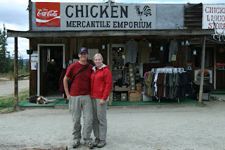
The Chicken Mercantile Emporium/Salooon/Cafe. As featured in National Geographic, this is downtown Chicken.


Chicken was the second incorpoorated town in Alaska. Its first residents were miners searching along the 40-mile river for gold. To survive the winters, many of the miners relied on eating Ptarmigan for survival. Many names were suggested for the town but as it turns out, no one could agree upon the actual spelling of "Ptarmigan". So the name "Chicken" was selected instead.

Beware of the Attack Chicken!

No camping on the landing strip! Quent and I found this sign to be hilarious. One wouldn't think that many campers would find a landing strip as the most attractive camping spot, but who knows!

Tuesday, January 20, 2009

South from Tok


From Tok, we travelled south on Tok Cutoff to meet up again with the Richardson Highway.

Travelling along, we noticed some white specks in a pond next to the road. As we moved closer, the white specks were identified as swans.


Our wonderful friends Quent & Christina were nice enough to let us use their telephoto lens to give us a closer look at the swans.


Right after seeing the swans, a fox trotted across the road.

A rainbow appeared along our trip, as well.

Near the end of the day, we stopped at a tributary of the Copper River near Gakona so the guys could fish. The sunset was beautiful.


Pat pretending to be a fisherman

Evening clouds from the bridge over the river.


Before leaving to head back to our campsite, we saw a beaver.